Abstract:
In the years of the Economical crisis in Greece (2009-2017), as well as after, the purchasing power of the Greek citizens in the major cities fell by 23%, making them in most of the cases, unavailable to cover their fundamental needs. As a result, people started to find alternate ways of producing at a very low cost which in turn also provided them with better quality organic produce. This gave birth to a new urban dynamic in cities around the country – “urban farming”. Small scale projects, with a bottom only structure started to appear, mainly in abandoned open public spaces, like parks and empty unbuilt sites, as well as on the rooftops of multi-story residential buildings. This dynamic continues to exist as a legacy from the last decade, as one of the most efficient ways of small-scale food production, with the engagement of local communities. However, this legacy did not achieve to be transformed into bigger scale projects, such as green urban hubs and community centers, that are distributed strategically in the city. This project aims to find a site and design the parameters of how the site may be used as a park for urban farming but also act as the heart of the neighborhood drawing people and providing them with a public space to enjoy.

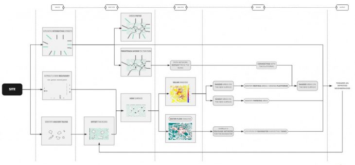
Figure 1: Methodology
The site we chose to investigate is Plato’s Academy Park in Athens, Greece. The park is part of the neighborhood of Akadimia Platonos (Plato’s neighborhood). This area of rich ancient ruins started undergoing excavations in 1929, and this continues till date. The neighborhood is partly industrial but mostly consists of housing developments. In understanding the site, the multiple existing elements in the park were studied. The ones selected to remain on site and taken into consideration for driving the project were the archaeological ruins such as the ancient gymnasium, groves, Plato’s square, etc.
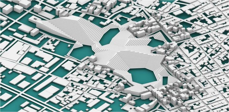
The ruins were assigned with a “safe zone” surrounding them. Then from their borders, using Bowerbird contour curves were offset to construct a new terrain. Multiple iterations of the terrain were explored before choosing the desired outcome.

Figure 2: Terrain Iterations

Figure 3: New Terrain
Using the Ladybug tool, a solar analysis was performed to allocate the respective programs to the different areas of the park. The areas with the highest amount of sunlight are the new slopes that are assigned for the farmland. The areas with medium sunlight are where the lightwells are placed to lit up the structures housed beneath the new terrain. The cooler areas are assigned for the resting areas and viewing platforms from where visitors can enjoy the old ruins.

Figure 4: Zoning of the Park
A similar process was carried out using Anemone for the water flow analysis on the site. This resulted in the identification of where to place the drainage network and the location of the water collection points. The water tanks are placed at the edges of the park that can only be accessible for the residents of the neighborhood.

Figure 5: Water Drainage System
The next step was to introduce a pedestrian network, for which the wooly paths were used. Iterations were made by changing the logic of the extension of the street axis and it’s intersection with the area of the ruins.

Figure 6: Circulation Network Iterations
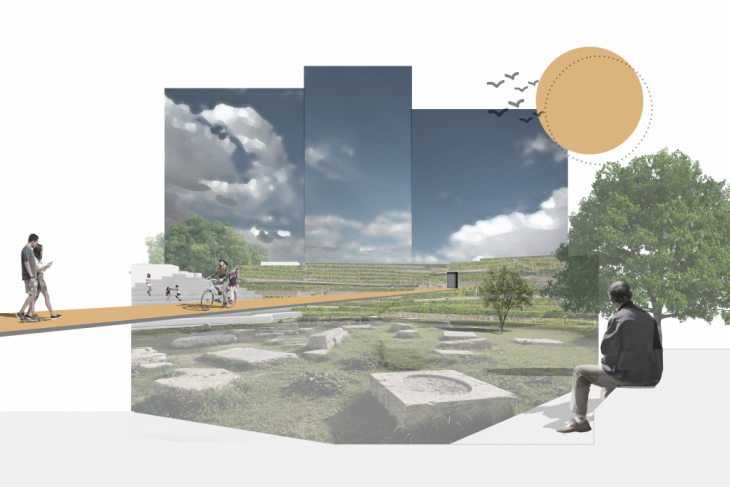
Once the pedestrian pathways were overlaid, they intersected with the new terrain at points to travel through the new structures placed beneath. A visitor would constantly go up and down, in and out while travelling through the landscape.
Lastly, for the impact of the park to filtrate into the neighborhood, the shortest paths from the park to the edge of the neighborhood were calculated. These paths could adopt the green from the park and spread as they stretched into the rest of the area becoming the “greener streets”.

Figure 8: Visualization of the Archaeological Ruin and new Pedestrian Pathways
“Above the Ruins” is a project of IAAC, Institute for Advanced Architecture of Catalonia developed in Master in City & Technology, 2021/2022 by Students: Aida Hassan, Dimitris Lampriadis, Maria Magkavali, Julia Veiga and Faculty: Eugenio Bettucchi, Iacopo Neri