+ ABSTRACT
By 2050, 68% of the world population will be living in cities. In order to best accommodate this rapid urbanization growth while making cities more sustainable, designers must find creative solutions for the big challenges that are going to arise from this reality. Food production, as highlighted in the SDG by the UN, is one of the most pressing challenges that we need to address within the next 10 years. This study focused on the hidden potential that traditional and informal roof surfaces can have for urban farming in a third-world environment to help alleviate the food production crisis and create micro economy opportunities for low-income communities.
The approach of this study spans three different scales: macro, meso, and micro. This methodology helped us discover the potential applications at a city level, connected with meso realities of each area, and finally implemented and tested at a micro-level on a real-case rooftop of Kampala, Uganda. This research explores the use of existing GIS and open databases to register and map the quantity and quality of the existing rooftops and couple this with the latest computer vision technology to alleviate the man-powered need to complete these datasets.
+ INTRODUCTION
The world around us is rapidly changing, affected by multiple factors like climate, politics, technology, and demographics. These factors are not just introducing new dynamics to which we need to adapt but also creating new sets of challenges and problems we need to face. Governments, policymakers, regulatory bodies, etc, have mostly, for the past decades, turn a blind eye to these matters in regards to more pressing short-term issues.
Thanks to a series of recent developments like the Sustainable Development Goals, driven by the United Nations, these major global issues have been addressed, explored, and communicated at an international level. This has led the global community to start openly discussing the current and future challenges and put together a comprehensive agenda that serves as a guiding manual to navigate them.
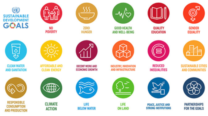
Since then, we as designers, have had the opportunity to focus our efforts on new and alternative ideas that can help us get closer to these goals. Because of this, we have decided to use this thesis to research and explore the possibilities within the architectural and urban design field to alleviate some of these pressures.
+ PROBLEMATIC & OBJECTIVES
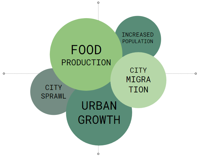
We narrow the research to the intersection of three major components: Architecture, food production, and increased population. Beyond the obvious challenges, cities need to be able to find a new way to produce, distribute, commercialize and process up to 10 times more the amount of food. This also needs to be done sustainably, without compromising food quality, diversity, and most importantly, carbon footprint. Cities will have to face major issues like the lack of available land for food production where most than 80% of the city area is occupied by buildings; the need for quality infrastructure to support centralized growth as 70% of global water consumption is used for farming; the need for a well-connected distribution network to get the fresh product to different regions as on average vegetables travel approximately 2,400km from farm to the consumer; and finally, a circular way to deal with wastage, as 33% of the world’s food goes to waste every year (Rajkumar, Paulrajan, 2010).
Based on these challenges, we want to research and explore, from an urban and architectural scale, different approaches to achieve the following:
- Explore, from a macro level, the potential of a city to produce all the vegetables it produces based on its population growth.
- Understand how can we make use of existing elements like roofs surfaces, residual areas or abandon spaces to re-activate by giving them a new function
- Understand how more advanced farming techniques, like hydroponics and aeroponics, help us to incorporate farming into the cities.
- Prototype new systems that can be retrofit into existing buildings within the city to enable rooftop farming
+ PROJECT METHODOLOGY
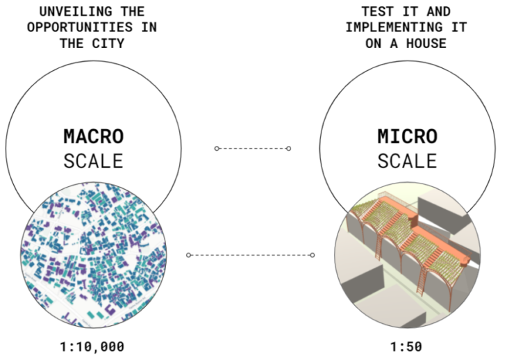
Based on the objectives specified above, we decided to phase our project onto a two-stage approach that goes from a macro to a micro implementation (Fig 2). This approach allowed us to explore and understand the global possibilities, opportunities, and constraints of an urban area and then jump onto the microscale where we can prototype real-case solutions that can fit the built environment.
We choose the neighborhood of Gabba, located on the southeast side of the city of Kampala, Uganda (Fig 3). Despite its growing economy, it is one of the poorest countries in the world. In 2012, 37.8 percent of the population lived on less than $1.25 a day and in 2009 24.5 percent of the population lived in poverty. Farming is one of the most common sources of income for most Ugandans and as far as 90 percent of all rural women work in the agricultural sector (Sabiiti et al., 2014).
In addition to agricultural work, rural women are responsible for the caretaking of their families. The average Ugandan woman spends 9 hours a day on domestic tasks, such as preparing food and clothing, fetching water and firewood, and caring for the elderly, the sick as well as orphans. This city is already having a crisis in food production and lacking empty farming spaces on the ground level, and this is what makes it a perfect candidate to test and explore our theory.
+ MACRO SCALE
The macroscale was focused on creating a live database of all the existing structures and buildings within the study area. This database was created by merging multiple existing sources onto a unique set that managed to capture position, area, levels, roof condition, structural condition, roof type, population, and the roof slope. Once we have identified the characteristics and unique conditions of each building within the study area, we then proceed with the next scale.
WORKFLOW
Once we established the overall approach, we mapped and developed the data workflow (Fig 4). The first step was to start gathering all available data related to the site and its context. We make use of three different sources: Building shapes and positions extracted from OpenStreetMap website service, roof conditions and materiality from Open Cities Africa, and population factors extracted from the Uganda Open Map service.
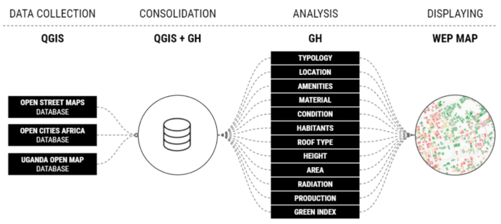
Once the data was collected, we used both QGIS and Grasshopper to consolidate and map the ids of each source onto a combined database. This allowed us to have a centralized data source that can be queried for multiple purposes.
ANALYSIS
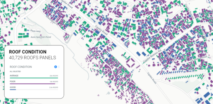
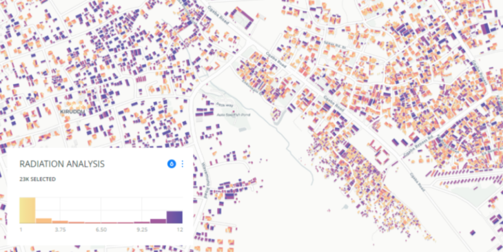
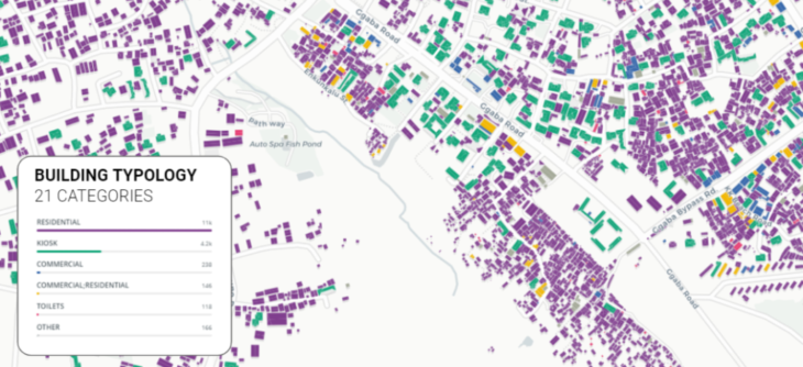
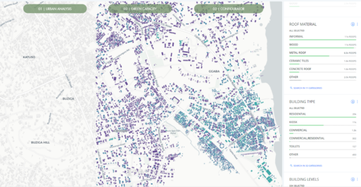
We used Grasshopper to analyze and process all the different fields available to us and to create a series of environmental and structural analyses, such as wind, radiation (Fig 5), materiality, typology (Fig 6), and condition (Fig 7). This allows us to understand the current conditions and characteristics of each roof panel across the entire area of study.
GREEN PRODUCTION CAPACITY
Once we have understood the existing conditions of the area, we then proceed to calculate the GPC index. This is an index calculated based on the following parameters:
- Location: Proximity to the center of the neighborhood
- Amenities: Amount of amenities within a 100 mts radius
- Roof Materiality: Type of roofs
- Roof condition: Current condition of the roof structure
- Roof Type: Flat – Skillon – Gabled – Hipped
- Area: Size of the usable roof for farming
All the existing roof panels within the study area were scored based on these parameters from a 1 to 5 scale. As a result, we had 40,729 roof surfaces scored across 6 different categories.
K-MEANS CLUSTERING
To group all the existing roof surfaces based on 6 different categories, we used an unsupervised machine learning algorithm called K-Means clustering. This allowed us to cluster them based on the following criteria:
- Not Possible: All roof surfaces that are not suitable for roof farming due to their materiality, poor condition, small area, etc.
- Not Optimal: All roof surfaces that, with intervention, can be used in the future for farming.
- Suitable: Surfaces with suitable existing conditions but with low performance.
- Good: Surfaces with good conditions and average performance.
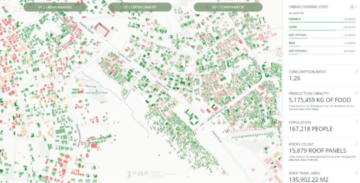
- Best: Roof surfaces that have the best qualities for an efficient urban farming system.
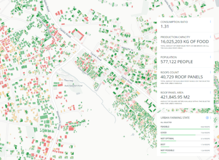
The k-means clustering was run in a python environment in visual studio and connected with Grasshopper using Hops. All the final values were packaged and presented onto a web-based map application (Fig 8) using Mapbox and Carto systems where the user can navigate through all the available roofs and check their suitability for urban farming.
+ FARMING SYSTEMS
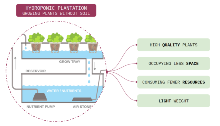
Farmers in Uganda, as well as across the world started to use the advantages of hydroponics. This is the technique of growing plants without soil, where the roots receive a balanced nutrient solution that contains water and all the nutrients essential to the development of the plant (Rajkumar and Paulrajan, 2010). This system has many benefits, such as producing high-quality plants, occupying less space, and consuming fewer resources.

ROOFTOP FARMING
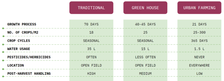
Urban rooftop farming is the development of farming activities on the top of buildings by taking advantage of the available spaces on roofs or terraces and it is part of the building-based urban agriculture that has recently occupied built infrastructures (Sanyé, Mengual, and Esther, 2015). Farmers in Uganda started to use their rooftops, towards a vertical resilient farming approach, whether for their daily use or commercial farming.

HYDROPONIC CROPS
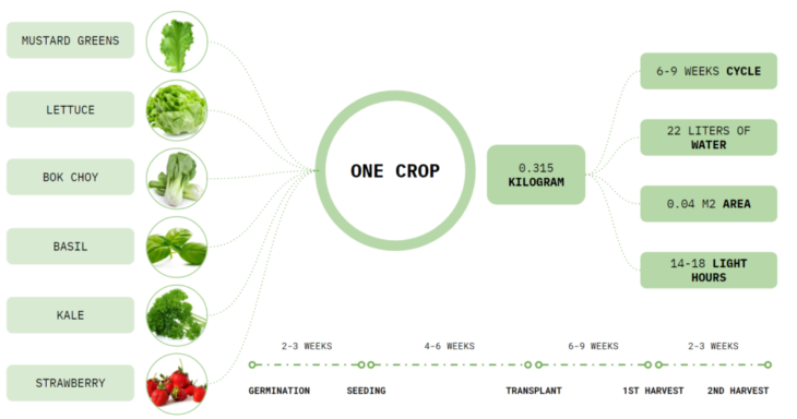
The most commonly grown crops in Kampala city are banana (cooking, beer, and sweet types), cassava, maize, beans, vegetables (leafy greens, cabbage, tomatoes, onions, bitter Tomatoes, etc.), spices, potato, cocoyam, mushrooms and fruit (jackfruit, avocado, pawpaw, mango, etc.). The studies show an approximate plant density of 24 plants per square meter where the mass of edible lettuce per plant was averaged from two sources to get an average mass of 144.6 grams per plant. Using the estimates for plant density, the number of harvests and plant mass, the average yield of hydroponic lettuce per year was calculated in units of kg/m2/y. This equation calculates the production of the annual crop per roof area.
+ MICRO SCALE
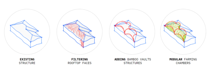
On this scale, we evaluate the different rooftop surfaces within one building to choose the best fit surface based on the orientation, area, slope, and sunlight access. Our proposal explores the concept of building a lightweight structural system made of natural local materials where load forces directions could be optimized by the structure shapeshifting techniques and by utilizing active bending properties of natural local materials such as bamboo. A parametric model is designed for such an adaptive structure to be able to fit the complex geometries of the different rooftop surfaces.
DESIGN WORKFLOW
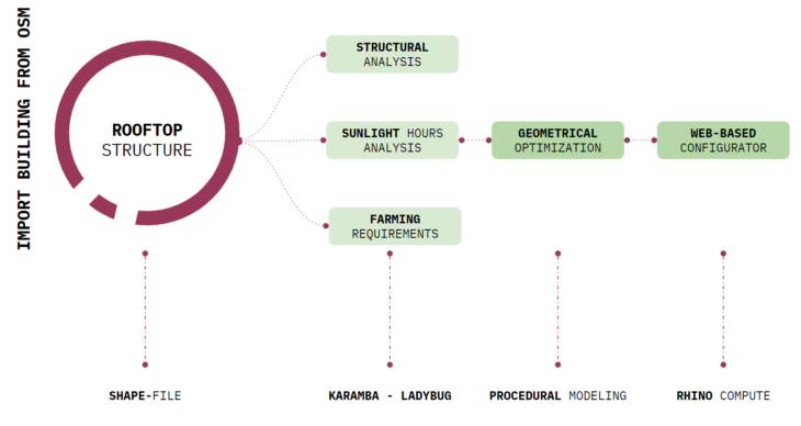
As shown in (Fig 10) the microscale design workflow is divided into the following phases:
- Importing the polygon of a building from open street maps into Grasshopper3d using SHAPE files.
- Analyzing the structural system of the rooftop geometry to evaluate the loads’ flow to the ground level using the Karamba3d Grasshopper plugin.
- Analyzing the sunlight hours of the rooftop to evaluate the sun access within the surroundings.
- Applying farming ergonomics based on the needed movement between farming lines, and the required slope to accommodate the water flow within the structure using gravity forces.
- Optimizing the farming system geometry to enhance the structural performance and the water flow cycle within the sloped water tubes.
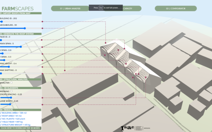
- Deploying the parametric model on the web using Rhino Compute and THREE JS to allow public users to access and evaluate different housing prototypes rooftops.
OSM TO GRASSHOPPER3D WORKFLOW
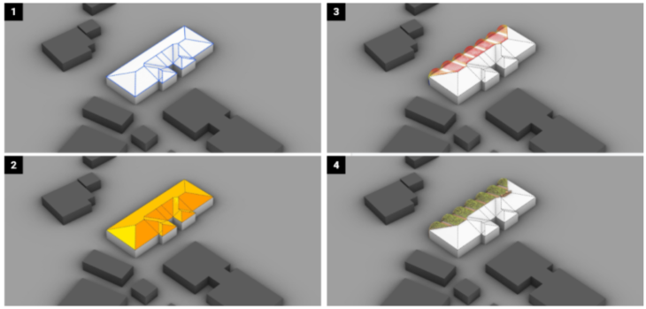
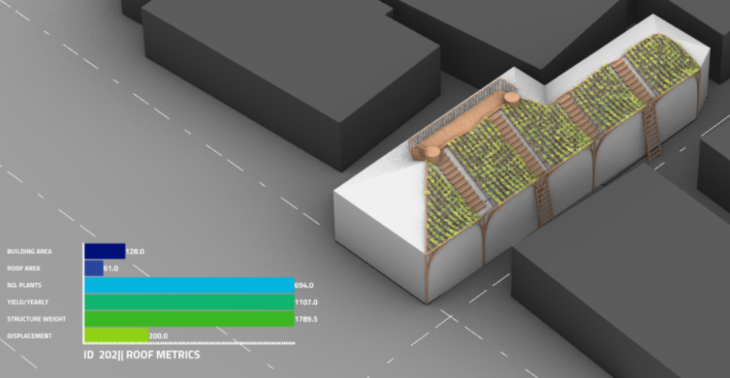
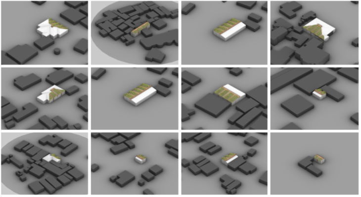
Each building was given an ID and imported to Grasshopper3D using shapefiles. A recursive system was developed to parse one building each loop and analyze its rooftop. The purpose of this process is to create our rooftop farming system metrics extracted from OSM buildings. At each step, we were able to extract roof area, max number of crops, annual food production, and structural features.

FARMING SYSTEM COMPONENTS
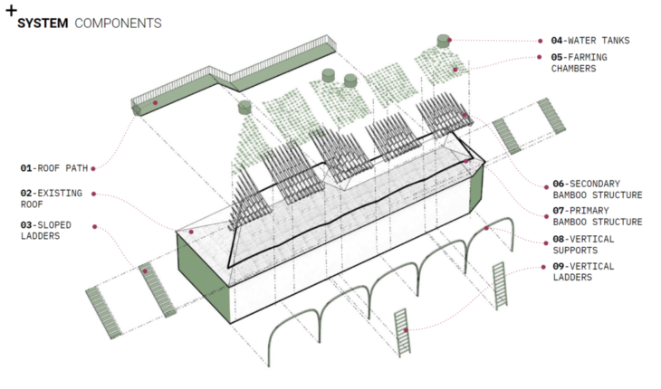
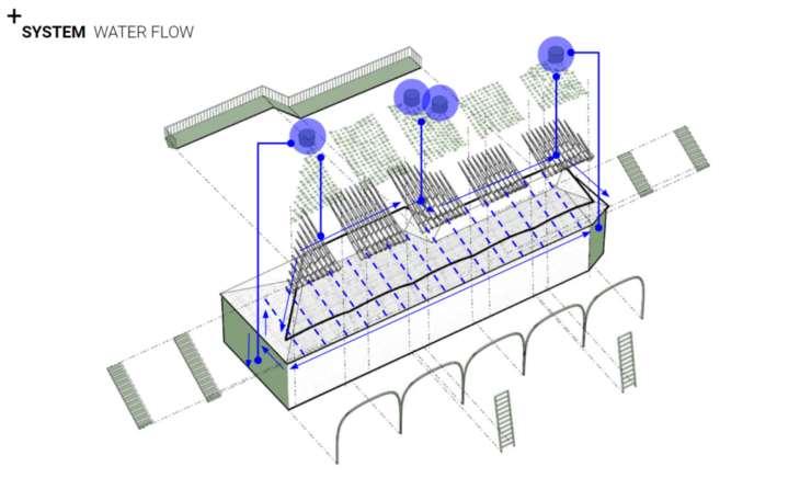
As shown in Figure 9, the proposed hydroponic farming system could be fabricated using local materials and traditional assembling techniques. The irrigation water system should be integrated with the existing house infrastructure and by adding a water pump at the ground level. The vertical staircases are enhancing the bottom-top connectivity for local farmers. Two water tanks are added to the highest level to store water, and the sloped pipes should be enough to carry water down to the crops. Finally, the main arcade structure system is taking care of carrying the load shared with the existing house structure.
+ WEB APPLICATION
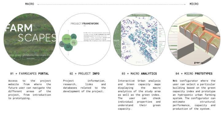
In this last step of our research, we created a web application to give the public users and farmers in Kampala city the opportunity to evaluate their rooftop space at the macro scale, and to build their rooftop farming system at the micro-level. The user can access a web map of Kampala, where the user can navigate through the different features. The user will also have access to the building’s rooftop condition, roof material, and building type
+ CREDITS
FARMSCAPES is the final thesis of IAAC, Institute for Advanced Architecture of Catalonia developed in the Master in Advanced Computation for Architecture & Design in 2020/21 by Hesham Shawqy and German Otto Bodenbender. Faculty: Angelows Chronis