Abstract
This study aims to apply digital environmental analysis tools to a specific site in the early design stage, so we have valuable data to make more informed decisions about the project.
Site
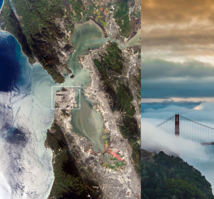
We have chosen the city of San Francisco, California, as the base for our studies. San Francisco is a peninsula located in the Bay Area surrounded by Marin to the North, Oakland (East Bay) to the East, and Silicon Valley to the South. The gap in terrain between San Francisco and Marin, combined with the presence of the Bay, creates a funnelling effect of the various meteorological phenomenon, resulting in San Francisco experiencing large amounts of fog and colder temperatures and more cloud cover than its surrounding areas.
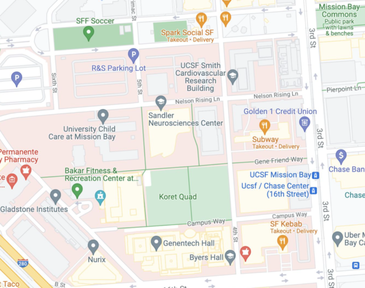
Within San Francisco, we have chosen an open park called Koret Quad. What started as a vast repository for debris that buried the pre-existing wetland, the area was transformed into a shipyard and railyard before undergoing significant redevelopment beginning in 1998. While preserving historic piers along the Bay, the new development included additional residential areas, a University of California, various corporate developments, and the reservation of 49 acres for public open space.
Climate Analysis
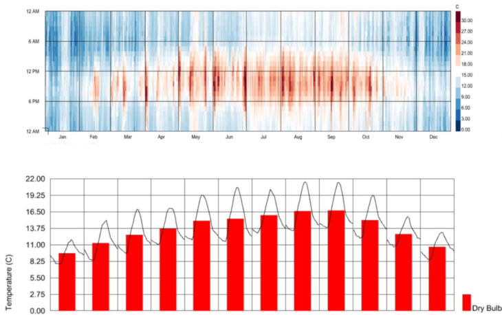
San Francisco has a very moderate climate with temperatures typically between 5-13 C in the colder months (Nov – Apr) and does not go above 30 C on the hottest days. There is a more significant average daily swing in temperature (almost 10 degrees) in the warmer months compared to the winter months (~5 degrees swing), resulting in the summer days being very warm in the days and very cold at night.
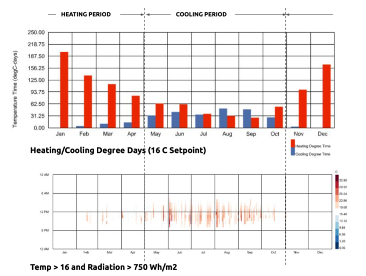
We looked at an annual plot of times when the temperature was above 16 C and radiation above 750 Wh/m2 in addition to the degree-days plot to better fine-tune and determine the times when the site would heat up a lot and require cooling. So, for example, even though the degree-days plot says there is the heating time required in the summer months, from the previous annual dry bulb plots, we know that this heating time would most likely only occur during the nights when the building wouldn’t be occupied anyway.
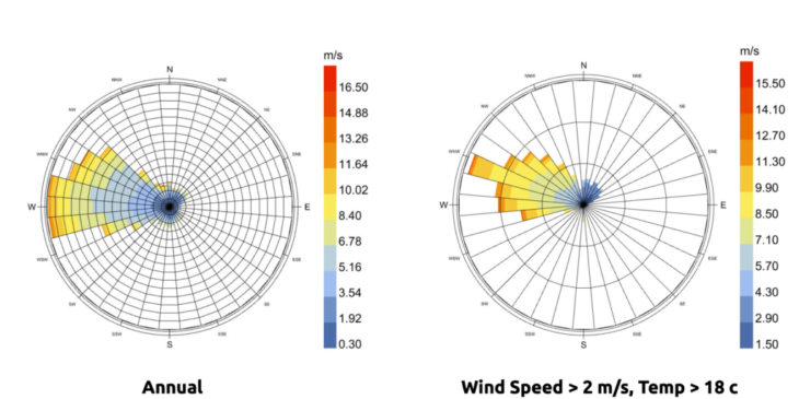
The site experiences strong winds, up to 15 m/s, with the highest winds occurring in the evenings of the summer months. Therefore, we looked at a plot of times when the wind speed is greater than 2 m/s, and the temperature is above 18 C to determine if natural ventilation could be a viable option in the warmer months. We found that of the times that the temperature was above 18 C, there was also enough wind to potentially provide passive cooling.
Initial design
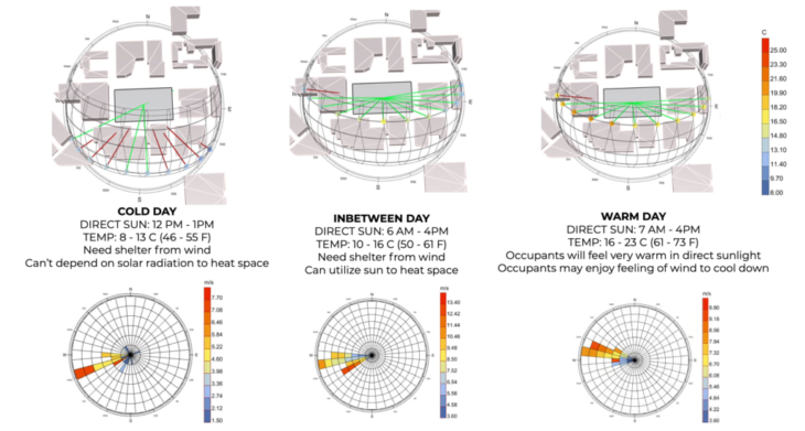
When considering the initial influencing factors of our design, we realized that choosing the more prevalent design state was fundamental. Therefore, we decided to design for passive heat gain after our studies.
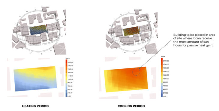
Therefore our building will be placed in the site area with the most sun hours for passive solar gain.
For the shape of our building decided to start with a tower of 12 floors with a cutout mass. We did several studies and eventually changed our building mass to achieve more significant optimization.
Design Optimization
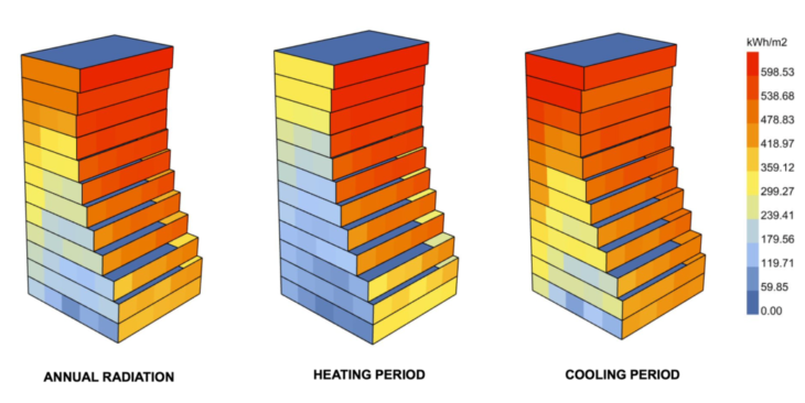
Using an initial geometry consisting of a series of rectangles that get lofted together to generate a mass, we ran a generative optimization of the tower using Galapagos. The form was optimized to maximize volume and radiation during the cooling period.
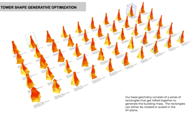
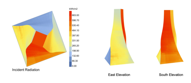
Our optimal final geometry maximizes surface area on east and west facades and minimizes north-facing elevations.
Shading was added in the form of balconies to help prevent overheating in the summer months.
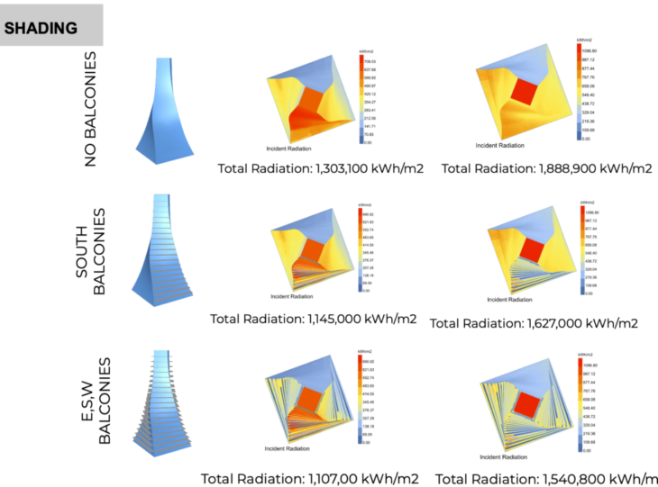
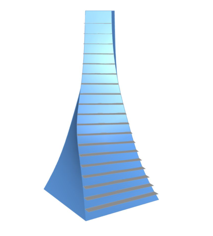
Balconies on the south were preferred due to their ability to block high angle sunlight in the summer and permit low angle light and radiation in the winter.
Adding balconies to the E, S, and W did little to reduce cooling period radiation and considering the amount of extra material required to build the additional balconies was not deemed a worthwhile option.
Our final selected geometry is shown below:
CFD studies
Using Infrared, we ran a series of CFD studies on our site, as shown below.

The site without a building is very comfortable, with only minor areas of high wind speeds at building corners and corridors.

Adding the building to the site creates a venturi effect to the north of the building and higher wind speeds at the southwest corner.
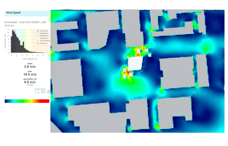
Trees were added where the wind speeds were highest. This slightly reduced the wind speeds in this area and improved wind comfort.
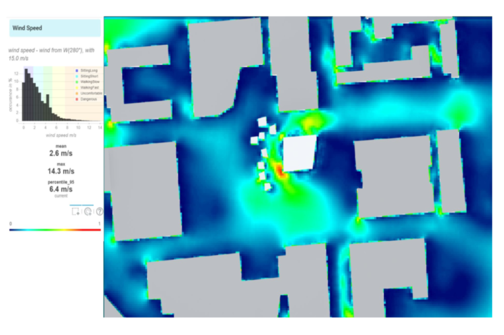
The trees were moved outward or “upstream” to block the wind before it reached the building. However, this also did little to improve conditions and actually increase the venturi effect around the building.
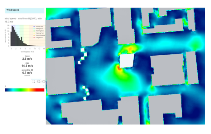
The trees were moved even further upstream to block the wind at the entrances of the corridors. Unfortunately, this did nothing to reduce wind speeds around the building.
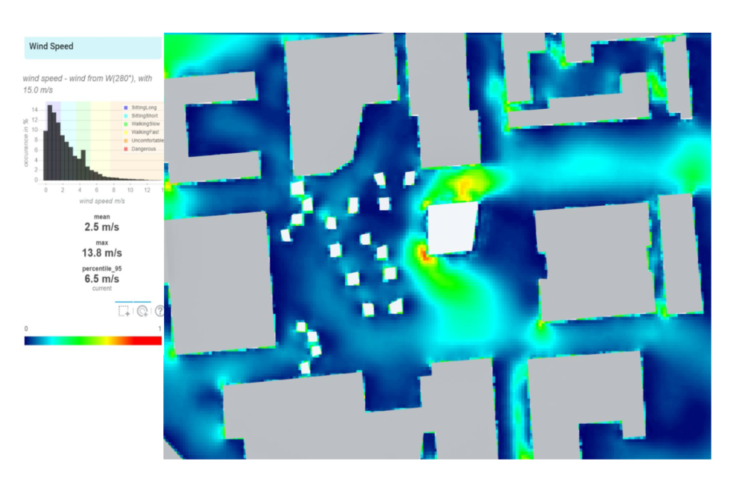
In a final attempt to reduce wind speeds, trees were placed at the ends of the corridors and surrounding the building, but a slight improvement was made. This is likely because the trees were modelled as solid objects with sharp corners instead of more organic shapes that can let some wind through.
Conclusions
The information generated with the Lady Bug plugins and InfraRED is super valuable to make the correct design decisions early in the concept design of our projects. By using them correctly, we can improve our design without adjusting at a later stage when the process is more advanced, causing abortive work.
Credits
Koret Quad is a project of IAAC, Institute of Advanced Architecture of Catalonia developed at Master In Advanced Computation For Architecture & Design in 2021/2022 by students: Sophie Moore and Bruno Martorelli and Faculty: Angelos Chronis, Aris Vartholomaios, Hager El-Sokaily